


Greater Angkor
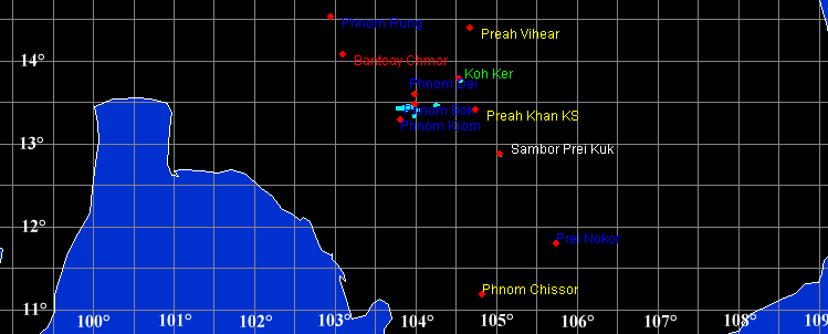
Central and Southern Hinterland of Angkor ( Whole hinterland) Temples list and maps


Central shrine of Banteay Srei
Courtesy of Moyra Farrington

Guardian lion of East Mebon
Plan of Koh Ker (Aymonier)


Phnom Bakheng temple

Bakong temple
Size of this preview: 182 × 243 pixels
Full resolution (1,704 × 2,272 pixels,
file size: 426 KB, MIME type: image/jpeg)
This file is licensed under
Creative Commons Attribution 2.0 License

Size of this preview: 305 × 391 pixels
Full resolution (507 × 650 pixels, file size: 83 KB, MIME type: image/jpeg)
GNU Free Documentation license
Size of this preview: 200 × 298 pixels
Full resolution (1,944 × 2,896 pixels, file size: 1.99 MB, MIME type: image/jpeg)
GNU Free Documentation license


BEFEO volume 39


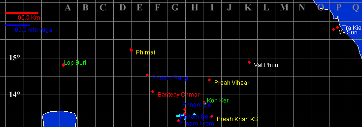
Northern Hinterland of Angkor ( Whole hinterland) Temples list and maps
Phimeanakas
Size of this preview: 800 × 531 pixels ; Full resolution (867 × 575 pixels, file size: 140 KB, MIME type: image/jpeg)
GNU Free Documentation license
GNU Free Documentation license


Angkor Wat Courtesy of Moyra Farrington
Beng Mealea Courtesy of Moyra Farrington


Ta Prohm
Courtesy of Moyra Farrington

Northern Angkor Proper Temples list and maps
This file is in the public domain because it was created by NASA
.(NASA copyright policy page or JPL Image Use Policy).
Copyright Robert Bywater & Jean-