Separation between London's and Manhattan's Cleopatra's Needles
Khmer sacred Geography
A set of interconnected planetary diagrams covering the Ancient Khmer Empire and brought to light by temples built on key locations reveals capacities, in the fields of astronomy, land-surveying and cartography, which exceed by far the know-how and accuracy previously attributed to Middle-Age scholars.
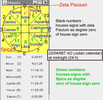
The basis of this research is the stanza XLIV of the inscription carved on the stele discovered in the fourth enclosure’s gopura of the Banteay Srei temple. We are able to demonstrate the stanza provides the houses-signs where the planets, the Sun and the Moon were located on 22 april 967 CE (Julian calendar) at midnight (24 h) although the indicated locations are not, at first sight, compatible with the year when the temple was consecrated. The « Siddhantic » software (HIC), created by Lars Gislén , calculates the following locations (figure here below) :
Sun, Mercury and Saturn (red numbers 1, 4 & 7) were located in the house-sign 0 (numbers written in black colour in the figure). With zeta Piscium used as degree zero (usual convention), the three objects were crossing, roughly, the Aries constellation. (more precise data provided by http://ancientcartography.net/22-04-967-midnight-4.pdf ) It is worth remembering the houses-signs were numbered from 0 to 11. ( F.G. Faraut : « Astronomie cambodgienne ») - Mars, Jupiter and Venus (red numbers 3,5 & 6) were located in the house-sign 11 which corresponded to Pisces. - The Moon (red number 2) was crossing the house-sign 4 which corresponded to Leo Those locations are confirmed by modern software.
The stele’s inscription provides houses-signs which don’t correspond to the month (nor to the year) of the temple’s consecration (22 April 967): - Sun, Mercury and Saturn are described to be in house-sign 6 (at first sight Libra). - Mars, Jupiter and Venus are described to be in house-sign 5 (at first sight Virgo). - Moon is described to be in house-sign 10 (at first sight Aquarius).
As a matter of fact, the locations provided by the inscription are fully correct if we suppose the degree zero of the first house-sign was Spica instead of zeta Piscium.
It is worth remembering the Indian (and the Khmer) used to measure the « ayanamsa » ie the difference of ecliptic longitude between the vernal equinox and the star used as degree zero of their zodiac. These stars were either Spica or zeta Piscium.
By using Spica (the house numbers become those written in green colour in figure):
- Sun, Mercury and Saturn in house-sign 6 ( Aries is house-sign 6 if Spica is degree zero).
- Mars, Jupiter and Venus in house-sign 5 (Pisces is house-sign 5 if Spica is degree zero).
- Moon in house-sign 10 (Leo is house-sign 10 if Spica is degree zero)
(Details on http://ancientcartography.net/22-04-967-midnight-4.pdf )
The Midnight system of Aryabhata and the Lunar model of Munjala
The stele of Banteay Srei and the planetary event of April 967
Notice
The Indians used apsides lines which were practically fixed with respect to the star used as degree zero (usually zeta Piscium) but the apsides lines were, of course, (due to precession) shifting with respect to the vernal equinox . As our current web page diagrams were drawn from ecliptic longitudes calculated from the vernal equinox (the only method used nowadays), we should have included the precession of the apsides from 499 CE (epoch of reference of Indian calculations) to 967 CE. Unfortunately, we did not include the precessional shift in the current web pages. The current diagrams will need to be corrected (but the differences are not great).
Oldest diagrams (22 April 967)
Later diagrams (15 April 967)
22/04 tables
15/04 tables
Other web pages of Robert Bywater and Jean-Pierre Lacroix
International Piri Reis Symposium (September 2004)
EAST ASIAN SHORELINES ON THE PIRI REIS MAP OF AH 919 (AD 1513)
From Bywater, R.A.R. and Lacroix, J.-P. (2004) Journal of Spatial Science
Antarctic continent on Piri Reis map : Map projections used in selected portulan style maps including the Piri Reis map of 1513
Wim van Binsbergen (Africa Studie Centrum) with the astronomical collaboration of Jean-Pierre Lacroix : Cupmarks, stellar maps, and mankala board-games (overview) An archaeoastronomical and Africanist excursion into Palaeolithic world-views
Cathedral of Chartres: lunar standstills
Egypt (Jean-Pierre lacroix) : Thebes: a reflection of the sky on the Pharaoh's earth
Copyright 2008 Jean-Pierre Lacroix & Robert Bywater
Last modification : 7 November, 2023